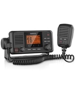
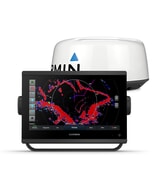
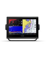
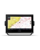
Garmin GPSMAP 922 Plus - Chartplotter Only
Free mainland UK delivery!
Advanced navigation. Ultimate integration. The 9” GPSMAP® 922 Plus touchscreen chartplotter features enhanced map drawing and seamlessly integrates into your Garmin marine system for full control of your connected helm.
Chartplotter Only - Does not have any built in Sonar capabilities.
- Physical Dimensions: 25.6 x 16.2 x 5.2 cm
- Display Size: 7.7" x 4.5"; 9.0" diagonal, (19.6 cm x 11.4 cm; 22.9 cm diagonal)
- Display Resolution: 1024 x 600 pixels
- Display Type: WSVGA display
- Weight: 1.2 kg
- Water Rating: IPX7
- Polarized Support: Yes
- Power Consumption: Max power usage at 10 Vdc: 27 W, Typical current draw at 12 Vdc: 1.2 A, Max current draw at 12 Vdc: 2.3 A
- Antenna: Internal or external over NMEA 2000
- Mounting Options: Bail or flush
- Receiver: 10 Hz high-sensitivity
- Garmin Marine Network Ports: 1
- Preloaded Maps: Worldwide basemap
- Accepts Data Cards: 2 microSD™ cards; 32 GB max
- Waypoints: 5,000
- Track Log: 50,000 points; 50 saved tracks
- Routes: 100
Advanced Navigation. Ultimate Integration.
The bright, sunlight-readable 9” intuitive touchscreen chartplotter with enhanced map drawing is easy to use in any environment and seamlessly integrates into your Garmin marine system.
- Easily integrate with more engines
- Connect to your favourite third-party devices
- Easily build your marine system using the best of network connectivity
- Compatible with premium maps and charts for the best in Garmin navigation
- Take the guesswork out of sailing with clear laylines and more, right on the screen
- Manage your marine experience from nearly anywhere
Navigate with ease.
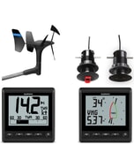
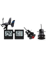
Garmin Sailassist Sailing Features
View laylines, race start line guidance, enhanced wind rose, heading and course-over-ground lines, true wind data fields and tide/current/time slider, wind angle, set and drift, wind speed and more.
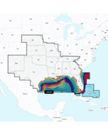
Optional Bluechart G3 Vision Charts
These optional charts offer the best of Garmin and Navionics data, Auto Guidance technology and other premium navigation features.
Connect to everything on your boat.
Garmin Marine Network
If you have multiple Garmin devices on your boat, you can share information — such as charts, user data, radar and IP cameras — among them.
NMEA 2000 and NMEA 0183 Networks
Connect to autopilots, digital switching, weather, FUSION-Link audio system, media, VHF, AIS and more from one screen.
Activecaptain App
Built-in Wi-Fi connectivity pairs with the free all-in-one mobile app for access to the OneChart feature, smart notifications, software updates, Garmin Helm, Garmin Quickdraw Community data and more.
Integrated ANT Technology
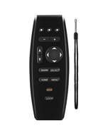
Connect with some of your favourite devices, such as quatix marine watches, gWind Wireless 2 transducers, GNX Wind marine instruments and wireless remote controls.
J1939 Connectivity
Now you can connect your chartplotter to different kinds of engines, including Yamaha engines.
Onehelm Feature
This exclusive feature brings together all the operations and capabilities of third-party devices, such as EmpirBus digital switching, on one screen.
-
-
-
-
-
-
-
-
-
 BEP Push Button Switch - Momentary (On) / Off - Red 24V£61.72 £51.43
 -
-