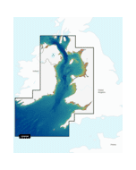
Garmin Navionics+ Chart: EU081R - Baltic Sea East Coast
Estimated Delivery 7 - 14 days
RRP £149.99
Coastal coverage of the Baltic Sea coasts of Poland, Russia, Lithuania, Latvia and Estonia from the German border to Narva-Joesuu, EE and the lakes and rivers of Poland, Belarus and the Baltic States. Coverage includes the Gulf of Riga, the Szczecin, Vistula and Kurshskiy Lagoons, the islands of Gotland, Saaremaa and Hiiumaa, the Oder, Vistula, Bug, Neman, Emajogi and Daugava Rivers, Lakes Peipus, Pihkva and Vortsjave, the Masurian District Lakes including Lake Jeziorak, Lake Lanskie and Lake Sniardwy and Lakes Snudy/Strusto, Miastra, Batorino, Lukomshoye and Selyava in Belarus. Ports include Tallinn, Estonia; Riga, Latvia; Gydnia and Gdansk, Poland and Kaliningrad, Russia. Supplied on a SD-Card (Micro SD With SD-Card Adapter).
- Navigate with our best offshore and inland lake coverage for your Garmin chartplotter
- See it your way. Customise your view with various chart layers and overlay combinations
- With your included one-year subscription access daily updates via the ActiveCaptain smart device app
- Auto Guidance+ technology lets you navigate with suggested dock-to-dock routings
- Select up to 10 colour-shaded target depth ranges to scope out the best fishing spots
It's A Whole New Look On Your Chartplotter
Featuring vibrant colours a streamlined interface and combined coastal/inland content with a popular Navionics style colour palette Garmin Navionics+ cartography makes it easy to plot your course with the world's No. 1 name in marine mapping.
Plot your paradise on coastal or inland waters.
All-In-One map Solution for Garmin Chartplotters - Access detail-rich mapping of coastal features lakes rivers and more. Integrated Garmin and Navionics content offers coverage for boaters worldwide.
Daily Chart Updates - Charts are constantly being enhanced with new and amended content - as many as 5 000 updates are made every day. The one-year included subscription gives you access to daily chart updates via the ActiveCaptain smart device app.
Auto Guidance+ Technology - Combining the best of Garmin and Navionics automatic routing features built-in Auto Guidance+ technology gives you a suggested dock-to-dock path to follow through channels inlets marina entrances and more.
Depth Range Shading - High-resolution depth range shading lets you select up to 10 colour-shaded options and view your designated target depths at a glance.
Up to 0.5m Contours - For improved fishing and navigation up to 0.5 m contours provide a clear depiction of bottom structure for improved fishing charts and enhanced detail in swamps canals harbours marinas and more.
Shallow Water Shading - To give a clear picture of shallow waters to avoid this feature allows for shading at a user-defined depth.
ActiveCaptain Community - Community-sourced content provides useful POIs such as marinas anchorages hazards businesses and more. Get recommendations from boaters with firsthand experience of the local environment.
Compatibility
The following devices are compatible with Garmin Navionics+ and Garmin Navionics Vision+ cartograghy
- ECHOMAP UHD (7" / 9")
- ECHOMAP ULTRA (10" / 12")
- GPSMAP 10x2 / 12x2
- GPSMAP 12x2 Touch
- GPSMAP 7x2 / 9x2 / 12x2 PLUS
- GPSMAP 7x3 / 9x3 / 12x3
- GPSMAP 8400 / 8600 / 8700 BB
-
-
-
-
 C-Map® Point Macdonnell To Tuross Head & Tas-4D£191.16 £159.30
 -
Octopus Drives CRA Hydraulic Constant Running Pump 24V 2 Litre / min£5,381.05 £4,484.21
-
-
 Simrad NSX® 9 in + Active Imaging 3-in-1 Transducer£1,572.17 £1,310.14
 -
-
-
BEP Circuit Breaker HD 100A Manual Reset Surface Mount£88.35 £73.62
-
-