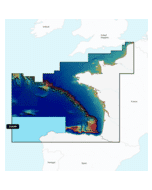
Navionics+ Chart Download Card - Compact Flash
Free mainland UK delivery!
Supplied as a Blank Compact flash Card with USB Adapter. Simply plug your Navionics Small Download chart medium into a PC or Laptop and choose from the selection of Charts to Download from the Navionics Website.
Also available in SD-Card Format here
Available Chart Areas:
- 28XG - UK, Ireland, Holland
- 46XG - Central & West Europe
- 43XG - Mediterranean & Black Sea
- 20XG - Greenland & Iceland
- 49XG - Norway
- 52XG - Russia West
- 45XG - Skagerrak & Kattegat
- 44XG - Baltic Sea
- 3XG - Caribbean & South America
- 50XG - Australia & New Zealand
Navionics+ Features
- Nautical Chart
- SonarChart
- Community Edits
- Daily Updates
- Dock to Dock Autorouting
- SonarChart Live
- Advanced Map Options
- Plotter Sync
Navionics+ provides complete inshore to offshore marine content, plus rivers, bays, and more than 40,000 lakes around the world.
The Navionics subscription
A one-year subscription to Daily Updates and advanced features is included when you purchase any new product.
After a year, you can renew at a discounted price.
Charts & Updates
Nautical Chart - comprehensive charts derived from multiple official, government and private sources, displayed in a familiar look and feel
SonarChart™ - innovative 1' (0.5 m) bathymetry charts created using Navionics proprietary systems
Community Edits - useful local knowledge from edits made by users of the Navionics Boating app
Daily Updates - Up to 5,000 updates to our charts every day.
Subscription Advanced features
Dock-to-dock Autourouting - start your trip with a suggested route
Advanced Map Options - customize your view
Plotter Sync - plan on mobile, go on plotter!
-
 Humminbird GM S15 - Gimbal Mount SOLIX 15 Models£163.31 £136.09
 -
-
-
 Simrad NSO evo3S 19 ” System Pack£6,913.68 £5,761.40
 -

-
-
-
 Garmin GMR 1234 xHD3 4' Open Array Radar 12kW Pedestal & 15M Cables
MPN: K10-00012-26£6,899.99 £5,749.99 -

-
-
-