Navionics+ Large Chart: EU643L - Mediterranean & Black Sea
Estimated Delivery 7 - 14 days
RRP £229.99
Navionics Charts are derived from multiple official, government and private sources, displayed in a familiar look and feel. Supplied on a SD-Card (Micro SD With SD-Card Adapter).
This chart replaces the following legacy areas:
- 43XG - Mediterranean & Black Sea
- Advanced Map Options
- SonarChart Live
- Dock to Dock Autorouting
- SonarChart
- Community Edits
- Nautical Chart
Navionics provides comprehensive charts derived from multiple official government and private sources displayed in a familiar look and feel.
The Navionics subscription: A one-year subscription to Daily Updates and advanced features is included when you purchase any new product.
After a year you can renew at a discounted price.
Charts & Updates
Nautical Chart: Comprehensive charts derived from multiple official government and private sources displayed in a familiar look and feel.
SonarChart: Innovative 1' (0.5 m) bathymetry charts created using Navionics proprietary systems.
Community Edits: Useful local knowledge from edits made by users of the Navionics Boating app.
Daily Updates: Up to 5 000 updates to our charts every day.
Subscription Advanced features
Dock-to-dock Autourouting: Start your trip with a suggested route
Advanced Map Options: Customise your view.
Plotter Sync: Plan on mobile go on plotter!
-

-
 Glomex 4 Way Nylon Ratchet Mount£26.91 £22.42
 -
-

-

-
-
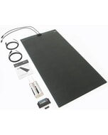 Solar Technology 200W MHD Flexi Top Exit Solar Panel Glue & 20A PWM
MPN: STPVFURT200£549.11 £457.59 -
-
-
 C-Map® Alicante-Max£274.22 £228.52