
Navionics+ Regular Chart: EU012R - Mediterranean Sea Cen. & West
Estimated Delivery 7 - 14 days
RRP £149.99
Navionics Charts are derived from multiple official, government and private sources, displayed in a familiar look and feel. Supplied on a SD-Card (Micro SD With SD-Card Adapter).
This chart replaces the following legacy areas:
- 530 - Calabria
- 531 - Sicilia
- 532 - Anzio - Amantea
- 533 - San Vincenzo - Salerno
- 534 - Liguria - P.Ercole
- 535 - Rapallo - Cavalaire
- 536 - Corse - N. Sardegna
- 537 - Sardegna
- 541 - Golfe Du Lion
- Advanced Map Options
- SonarChart Live
- Dock to Dock Autorouting
- SonarChart
- Community Edits
- Nautical Chart
Navionics provides comprehensive charts derived from multiple official government and private sources displayed in a familiar look and feel.
The Navionics subscription: A one-year subscription to Daily Updates and advanced features is included when you purchase any new product.
After a year you can renew at a discounted price.
Charts & Updates
Nautical Chart: Comprehensive charts derived from multiple official government and private sources displayed in a familiar look and feel.
SonarChart: Innovative 1' (0.5 m) bathymetry charts created using Navionics proprietary systems.
Community Edits: Useful local knowledge from edits made by users of the Navionics Boating app.
Daily Updates: Up to 5 000 updates to our charts every day.
Subscription Advanced features
Dock-to-dock Autourouting: Start your trip with a suggested route
Advanced Map Options: Customise your view.
Plotter Sync: Plan on mobile go on plotter!
-
-
-
 Humminbird GM H910 - Gimbal Mount HELIX 9/10 Models£81.12 £67.60
 -
-
 Glomex Satelite TV Dome Rhine Neo Satellite£4,937.14 £4,114.28
 -
-
 Glomex Uv Resistant Nylon Rail Mount - Black£21.63 £18.02
 -
-
-
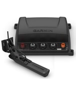 Garmin GCV 20 Sonar Black Box & GT34UHD-TM Transom Mount Transducer
MPN: 010-02055-00£540.40 £450.33 -
-
 Kicker KMC2 Marine Media Centre£202.81 £169.01