Navionics+ Regular Chart: EU062R - Russia, Upper & Central Volga
Ready to dispatch
Navionics Charts are derived from multiple official, government and private sources, displayed in a familiar look and feel. Supplied on a SD-Card (Micro SD With SD-Card Adapter).
This chart replaces the following legacy areas:
- 620 - Dolgoprudny - Tver
- 621 - Khimki - N. Novgorod
- 623 - Dubna to Rybinsk
- 624 - Vytegra - Rybinsk Res
- 625 - Rybinsk to Lyskovo
- 627 - N. Novgorod - Sengiley
- 628 - Ulyanovsk to Saratov
- 633 - Kazan to Ufa
- 634 - Lake Onega
- 635 - Lake Ladoga
- 636 - Ufa to Solikamsk
- Advanced Map Options
- SonarChart Live
- Dock to Dock Autorouting
- SonarChart
- Community Edits
- Nautical Chart
Navionics provides comprehensive charts derived from multiple official, government and private sources, displayed in a familiar look and feel.
The Navionics subscription: A one-year subscription to Daily Updates and advanced features is included when you purchase any new product.
After a year, you can renew at a discounted price.
Charts & Updates
Nautical Chart: Comprehensive charts derived from multiple official, government and private sources, displayed in a familiar look and feel.
SonarChart: Innovative 1' (0.5 m) bathymetry charts created using Navionics proprietary systems.
Community Edits: Useful local knowledge from edits made by users of the Navionics Boating app.
Daily Updates: Up to 5,000 updates to our charts every day.
Subscription Advanced features
Dock-to-dock Autourouting: Start your trip with a suggested route
Advanced Map Options: Customise your view.
Plotter Sync: Plan on mobile, go on plotter!
-
 Garmin GPSMAP 1623xsv - Chartplotter & Sonar£4,006.90 £3,339.08
 -
 Alfatronix DD Series 12-24VDC Voltage Converter - 240W (10A)£184.09 £153.41
 -
 Scanstrut Dual PowerTower Mount (Radome)£632.95 £527.46
 -
 Garmin Carbon Fibre Mast Bracket for 3x GNX 120£425.14 £354.28
 -
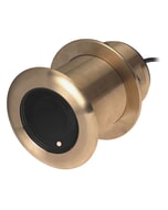 Garmin Airmar B150M 12° Tilt 8 Pin Bronze Thru-Hull Transducer£475.99 £396.66
 -
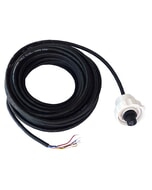 Airmar WX Series NMEA 2000 10M Cable£169.68 £141.40
 -
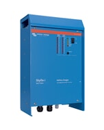 Victron Skylla-i Battery charger 24v/100a (1+1)£1,093.16 £910.97
 -
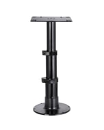 Osculati Giant Black Heavy Duty Table Pedestal - 345 - 714mm£623.00 £519.17
 -
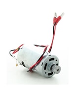 Raymarine Motor Assembly for ST2000 Tiller Pilot£80.00 £66.67
 -
 Humminbird HELIX 5 CHIRP GPS G3£353.74 £294.78
 -
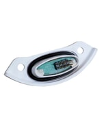 Airmar Humidity Sensor for WX - converts WX into IPX4 rated£233.44 £194.53