
Raymarine Lighthouse Chart Download Card: R70795 - Country - SD-Card
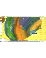
LightHouse Charts bring a new level of clarity to marine navigation. Created from official hydrographic chart sources, LightHouse Charts offer maximum readability, intuitive navigation, and superior quality. Four distinct color palettes provide the best possible viewing conditions around the clock and chart symbol controls give you the power to customize the charts to your personal preference.
Supplied as a Blank Micro SD Card to enable end user to select the chart of their choice to download from the Raymarine Chart Store
REQUIRES AXIOM OR ELEMENT RUNNING LIGHTHOUSE 3.12 OR HIGHER
- Enhanced Chart Symbol Control
- Flexible Color Modes
- Professional or Leisure Chart Style
LightHouse Charts bring a new level of clarity to marine navigation. Created from official hydrographic chart sources, LightHouse Charts offer maximum readability, intuitive navigation, and superior quality. Four distinct color palettes provide the best possible viewing conditions around the clock and chart symbol controls give you the power to customize the charts to your personal preference. Subscribe to LightHouse Charts Premium to access continuous chart updates, an expanded points of interest (POI) library, and enhanced satellite imagery for a powerful, sophisticated take on marine navigation.
Smart charts make navigating easier...
Enhanced Chart Symbol Control - Change the size of channel markers, points of interest, and other icons for complete control over chart details.
Flexible Color Modes - Day, Dusk, Dark, and Bright Sun color palettes help your vision keep up with changing light conditions for clear, strain-free chart viewing.
Professional or Leisure Chart Style - Toggle between the information-rich professional S-52 government chart style and the LightHouse leisure chart style for your preferred view of key cartographic data.
Discover more with lighthouse charts premium...
Stay Up to Date and Explore More - RayConnect Mobile and a LightHouse Premium subscription allows you to update your charts and download premium content using your mobile phone.
Navigate with a Real-World View - Access Mapbox-powered high-resolution satellite imagery for a complete view of streets, shorelines, and shallows for informed decision making.
Expansive Point of Interest Library - Quickly find local marinas, fuel stops, service stations, and more with an ever-expanding points of interest library from the best marine databases.
-
 BEP Magnetic Circuit Breaker - 30 A - Double Pole Trip Coil Pole£125.95 £104.96
 -
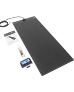 Solar Technology 150W MHD Flexi Top Exit Solar Panel Glue & 15A MPPT
MPN: STPVFURT150PT£628.00 £523.33 -
-
 Octopus Drives Intellisteer Type R - For Boats with Auxiliary Outboards£1,434.84 £1,195.70
 -
-
-
-
-
-
-
 Humminbird GM H12 - Gimbal Mount HELIX 12 Models£127.85 £106.54
 -
 C-Map® Angola Coasts-4D£214.40 £178.67