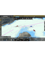
Navionics Platinum+ Regular Chart: US006R - US South
Estimated Delivery 7 - 14 days
RRP £239.99
Navionics Charts are derived from multiple official, government and private sources, displayed in a familiar look and feel. Supplied on a SD-Card (Micro SD With SD-Card Adapter).
This chart replaces the following legacy areas:
- HMPT-S6 - Hotmaps Platinum South
- 630 - East Gulf of Mexico
- 632 - Central & S Florida
- 635 - West Gulf of Mexico
- 642 - S Carolina - N Florida
- 651 - Central Gulf of Mexico
- 699 - N Bahamas
- 906 - US Southeast - Bahamas
- 907 - Gulf of Mexico
- Relief Shading (Platinum+ Only)
- SonarChart Shading (Platinum+ Only)
- Panoramic Port Photos (Platinum+ Only)
- 3D View (Platinum+ Only)
- Satellite Overlay (Platinum+ Only)
- Advanced Map Options
- SonarChart Live
- Dock to Dock Autorouting
- SonarChart
- Community Edits
- Nautical Chart
Navionics provides comprehensive charts derived from multiple official government and private sources displayed in a familiar look and feel.
The Navionics subscription: A one-year subscription to Daily Updates and advanced features is included when you purchase any new product.
After a year you can renew at a discounted price.
Charts & Updates
Nautical Chart: Comprehensive charts derived from multiple official government and private sources displayed in a familiar look and feel.
SonarChart: Innovative 1' (0.5 m) bathymetry charts created using Navionics proprietary systems.
Community Edits: Useful local knowledge from edits made by users of the Navionics Boating app.
Daily Updates: Up to 5 000 updates to our charts every day.
Subscription Advanced features
Dock-to-dock Autourouting: Start your trip with a suggested route
Advanced Map Options: Customise your view.
Plotter Sync: Plan on mobile go on plotter!
-
 Simrad NSS12 Evo3S 12 in Display With GPS£3,484.72 £2,903.93
 -
 C-Map® France North East Inland Waters-Max£274.22 £228.52
 -
-
 Quick BTQ 125-30 Single Prop Thruster - 30KGF 12V With Bow Casing
MPN: FGBT12530120TC0£1,154.38 £961.98 -
 Navico NF80£1,166.18 £971.82
 -
-
CZone Control X Plus - Interface Only£2,857.02 £2,380.85
-
-
-