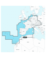
Raymarine Lighthouse Chart: R70794 - North America - SD-Card
Estimated Delivery 7 - 14 days
RRP £145.00
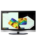
LightHouse Charts bring a new level of clarity to marine navigation. Created from official hydrographic chart sources, LightHouse Charts offer maximum readability, intuitive navigation, and superior quality. Four distinct color palettes provide the best possible viewing conditions around the clock and chart symbol controls give you the power to customize the charts to your personal preference.
- Enhanced Chart Symbol Control
- Flexible Color Modes
- Professional or Leisure Chart Style
- Includes 1 Free year of LightHouse Charts Premium Subscription
- Compatibility: Raymarine Axiom Axiom+ Axiom Pro Axiom XL and Raymarine Element.
LightHouse Charts bring a new level of clarity to marine navigation. Created from official hydrographic chart sources LightHouse Charts offer maximum readability intuitive navigation and superior quality. Four distinct color palettes provide the best possible viewing conditions around the clock and chart symbol controls give you the power to customize the charts to your personal preference. Subscribe to LightHouse Charts Premium to access continuous chart updates an expanded points of interest (POI) library and enhanced satellite imagery for a powerful sophisticated take on marine navigation.
Smart charts make navigating easier...
Enhanced Chart Symbol Control - Change the size of channel markers points of interest and other icons for complete control over chart details.
Flexible Color Modes - Day Dusk Dark and Bright Sun color palettes help your vision keep up with changing light conditions for clear strain-free chart viewing.
Professional or Leisure Chart Style - Toggle between the information-rich professional S-52 government chart style and the LightHouse leisure chart style for your preferred view of key cartographic data.
Discover more with lighthouse charts premium...
Stay Up to Date and Explore More - RayConnect Mobile and a LightHouse Premium subscription allows you to update your charts and download premium content using your mobile phone.
Navigate with a Real-World View - Access Mapbox-powered high-resolution satellite imagery for a complete view of streets shorelines and shallows for informed decision making.
Expansive Point of Interest Library - Quickly find local marinas fuel stops service stations and more with an ever-expanding points of interest library from the best marine databases.
Coverage
Coverage of the contiguous United States Alaska Hawaii Canada U.S. Virgin Islands Puerto Rico and Bahamas coastlines. Tides and currents information for planning and safety. Includes the Great Lakes and over 6 000 inland freshwater bodies of water. The river waterways of Arkansas Cumberland Illinois Mississippi Missouri Ohio Tennessee St. Lawrence and many more are covered. In fishing mode the entire U.S. Mainland coast is covered in a continuous 6-foot interval coverage the Great Lakes is covered in 1 foot intervals. Researched marked fishing areas for Coastal and inland lakes provided by Fishing Hot Spots. Premium point of interest data included from Marinas.com and Waterway Guides with subscription.
-
-
-
-
-
-
-
 Glomex Uv Resistant Nylon Rail Mount - Black£21.63 £18.02
 -
-
-
-